Geostationary Satellite
 The Images are based on data measured by the geostationary satellites MSG (Meteosat Second Generation).
The MSG satellites form a series of meteorological satellites operated by the European Organisation for the Exploitation of Meteorological Satellites (EUMETSAT).
From the perspective of an Earth based observer, geostationary satellites take a fixed position centered above the Equator.
This is due to the fact that geostationary satellites fly exactly one Earth orbit while the Earth does one rotation about its axis.
Geostationary satellites are located at a distance of about 36000km above sea level (42000km above the geocentre).
With a turning radius of about 42000km, this results in a circular path length of 264000km, a distance that is covered by the satellite in 24h, thus at a speed of 11000km/h.
To stabilize the flight of MSG along its circuit, the satellite has an additional spin of 100rpm.
The Images are based on data measured by the geostationary satellites MSG (Meteosat Second Generation).
The MSG satellites form a series of meteorological satellites operated by the European Organisation for the Exploitation of Meteorological Satellites (EUMETSAT).
From the perspective of an Earth based observer, geostationary satellites take a fixed position centered above the Equator.
This is due to the fact that geostationary satellites fly exactly one Earth orbit while the Earth does one rotation about its axis.
Geostationary satellites are located at a distance of about 36000km above sea level (42000km above the geocentre).
With a turning radius of about 42000km, this results in a circular path length of 264000km, a distance that is covered by the satellite in 24h, thus at a speed of 11000km/h.
To stabilize the flight of MSG along its circuit, the satellite has an additional spin of 100rpm.
|
Image Generation
 The main instrument on the MSG satellites is called SEVIRI (Scanning Enhanced Visible and InfraRed Imager).
SEVIRI measures at 12 spectral channels that are optimized for the measurement of meteorological parameters.
More information on the spectral channels is given in the section "spectral channels" below.
For (almost) each channel, SEVIRI has three detectors.
Thus, SEVIRI functions somewhat differently from a very expensive space based digital camera.
A digital camera is able to capture a whole scenery at once, because it has as many detector pixels as image pixels.
Instead, SEVIRI has only three detectors per channel and scans the image during the spin of the satellite.
When directed towards the Earth, SEVIRI detects three lines in East-West direction.
During the rotation, when the Earth is out of sight of SEVIRI, it changes its viewing direction slightly to the North, so that with the next rotation three more lines can be captured.
A complete scan of the Earth takes about 12 minutes, the resulting images consist of 3712x3712 pixels (4500x4500 pixels inclusive additional border). The distance between two pixels on the Earth surface is not identical everywhere. It is smallest where the viewing angle of the satellite instrument is 0°, thus at the point directly below the satellite.
At that point, the pixel distance is 3km.
In Europe, the pixel distance is about 4.5km.
The main instrument on the MSG satellites is called SEVIRI (Scanning Enhanced Visible and InfraRed Imager).
SEVIRI measures at 12 spectral channels that are optimized for the measurement of meteorological parameters.
More information on the spectral channels is given in the section "spectral channels" below.
For (almost) each channel, SEVIRI has three detectors.
Thus, SEVIRI functions somewhat differently from a very expensive space based digital camera.
A digital camera is able to capture a whole scenery at once, because it has as many detector pixels as image pixels.
Instead, SEVIRI has only three detectors per channel and scans the image during the spin of the satellite.
When directed towards the Earth, SEVIRI detects three lines in East-West direction.
During the rotation, when the Earth is out of sight of SEVIRI, it changes its viewing direction slightly to the North, so that with the next rotation three more lines can be captured.
A complete scan of the Earth takes about 12 minutes, the resulting images consist of 3712x3712 pixels (4500x4500 pixels inclusive additional border). The distance between two pixels on the Earth surface is not identical everywhere. It is smallest where the viewing angle of the satellite instrument is 0°, thus at the point directly below the satellite.
At that point, the pixel distance is 3km.
In Europe, the pixel distance is about 4.5km.
|
Spectral Channels
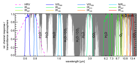 SEVIRI measures light radiance at 11 spectral channels with a resolution of 3km at the nadir point directly below the satellite.
An additional channel has a nadir resolution of 1km.
However, as this channel does not cover the entire visible disc, it cannot be used for Moments from Space images.
The 3km channels measure at spectral wavelengths of 0.6, 0.8, 1.6, 3.9, 6.2, 7.3, 8.7, 9.7, 10.8, 12.0, 13.4µm.
Light that is visible for the human eye has wavelengths between ca 0.38µm and 0.78µm.
Thus, only the 0.6µm channel is located in this range.
The other channels are located in the near infrared (used e. g. for night-vision glasses) and in the thermal infrared (used e. g. for thermal images).
The channels are defined in a way in which they are well suited for the retrieval of meteorological properties.
SEVIRI measures light radiance at 11 spectral channels with a resolution of 3km at the nadir point directly below the satellite.
An additional channel has a nadir resolution of 1km.
However, as this channel does not cover the entire visible disc, it cannot be used for Moments from Space images.
The 3km channels measure at spectral wavelengths of 0.6, 0.8, 1.6, 3.9, 6.2, 7.3, 8.7, 9.7, 10.8, 12.0, 13.4µm.
Light that is visible for the human eye has wavelengths between ca 0.38µm and 0.78µm.
Thus, only the 0.6µm channel is located in this range.
The other channels are located in the near infrared (used e. g. for night-vision glasses) and in the thermal infrared (used e. g. for thermal images).
The channels are defined in a way in which they are well suited for the retrieval of meteorological properties.
|
True Color Images
 From the measurements of the 12 SEVIRI channels, it is not possible to easily generate figures that look like real photographs taken from space (true-color images).
This is due to the scientifically oriented conception of the satellite and the instrument.
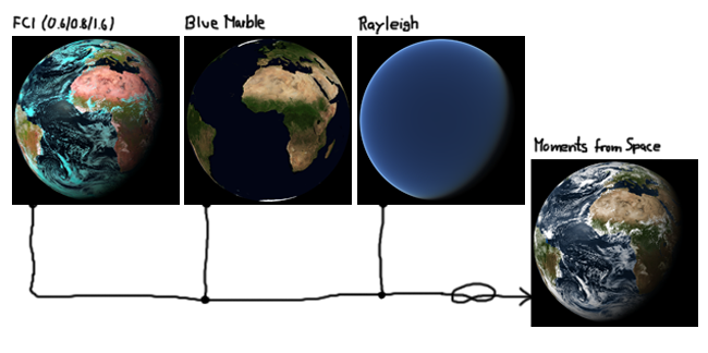
To produce real true-color images, information from the blue, the red and the green parts of the spectrum of light are needed.
The 0.6µm channel is well suited to provide information for the yellow to red spectral region.
Additionally, two channels in the near infrared (0.8µm and 1.6µm) are used to process a first image, which contains still false colors, due to the lack of information from the blue and green spectral region.
In the figure, this is marked by "FCI" (False Color Image).
The missing information result in turquoise ice clouds and pink desert regions.
To fill the gap of color information needed for true-color images, we used the "Blue Marble Next Generation" (BMNG) data of the US space agency NASA.
The BMNG data can serve as good approximation of the cloud-free Earth surface color.
By scattering of the sunlight at small particles in the atmosphere (Rayleigh scattering), the Earth looks blue seen from space.
Due to the choice of SEVIRI channels, this effect is not represented in the SEVIRI data.
Using a radiative transfer simulation, this effect has been calculated and superimposed on the image at the edges of the Earth disc.
A more detailed description of the algorithm is given in the scientific publication "Moments from space captured by MSG SEVIRI", which was published in the International Journal of Remote Sensing:
From the measurements of the 12 SEVIRI channels, it is not possible to easily generate figures that look like real photographs taken from space (true-color images).
This is due to the scientifically oriented conception of the satellite and the instrument.
To produce real true-color images, information from the blue, the red and the green parts of the spectrum of light are needed.
The 0.6µm channel is well suited to provide information for the yellow to red spectral region.
Additionally, two channels in the near infrared (0.8µm and 1.6µm) are used to process a first image, which contains still false colors, due to the lack of information from the blue and green spectral region.
In the figure, this is marked by "FCI" (False Color Image).
The missing information result in turquoise ice clouds and pink desert regions.
To fill the gap of color information needed for true-color images, we used the "Blue Marble Next Generation" (BMNG) data of the US space agency NASA.
The BMNG data can serve as good approximation of the cloud-free Earth surface color.
By scattering of the sunlight at small particles in the atmosphere (Rayleigh scattering), the Earth looks blue seen from space.
Due to the choice of SEVIRI channels, this effect is not represented in the SEVIRI data.
Using a radiative transfer simulation, this effect has been calculated and superimposed on the image at the edges of the Earth disc.
A more detailed description of the algorithm is given in the scientific publication "Moments from space captured by MSG SEVIRI", which was published in the International Journal of Remote Sensing:
M. Reuter, S. Pfeifer (2011): Moments from space captured by MSG SEVIRI. International Journal of Remote Sensing, 32, 14, 4131-4140, doi: 10.1080/01431161.2011.566288
 .
.
|